A sustainable village grows conversation in the street. Talking in public is an essential element of village life. These are streets where the car is a guest and people may enjoy themselves.
The trial demonstration projects that are proposed are:
- making the street a shared zone with walking speed in the whole suburb;
- cool streets;
- pop-up cafes and a pop-up roundabout;
- self-irrigating pop-up median strips;
- volunteer weekend lane closures;
- incentives to encourage people to use car-share services; and
- engagement of the community with garbage collectors, parking inspectors and rangers through road gardening and maintenance.
The Sustainable Streets and Community Plan aims to create a suburb where pedestrians and cyclists can safely travel.
Without a transport plan the suburb will not be sustainable. Air pollution from vehicles will continue at unhealthy levels, obesity will continue to increase with significant health and cost burdens for residents and businesses, and the village amenity will continue to be eroded. A transport plan can prevent these problems increasing and support City of Sydney Council’s 2030 Vision.
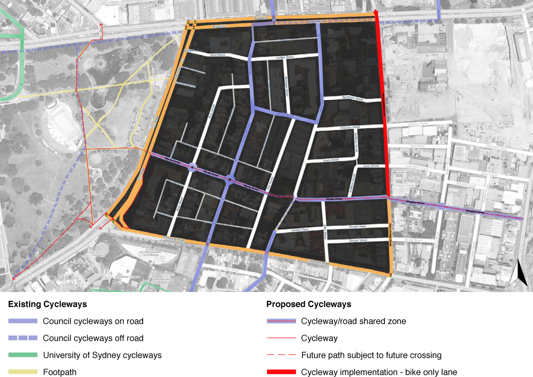

- Council cycleways on road

- Council cycleways off road

- University of Sydney cycleways

- Footpath

- Cycleway/road shared zone

- Cycleway

- Future path subject to future crossing

- Cycleway implementation – bike only lane
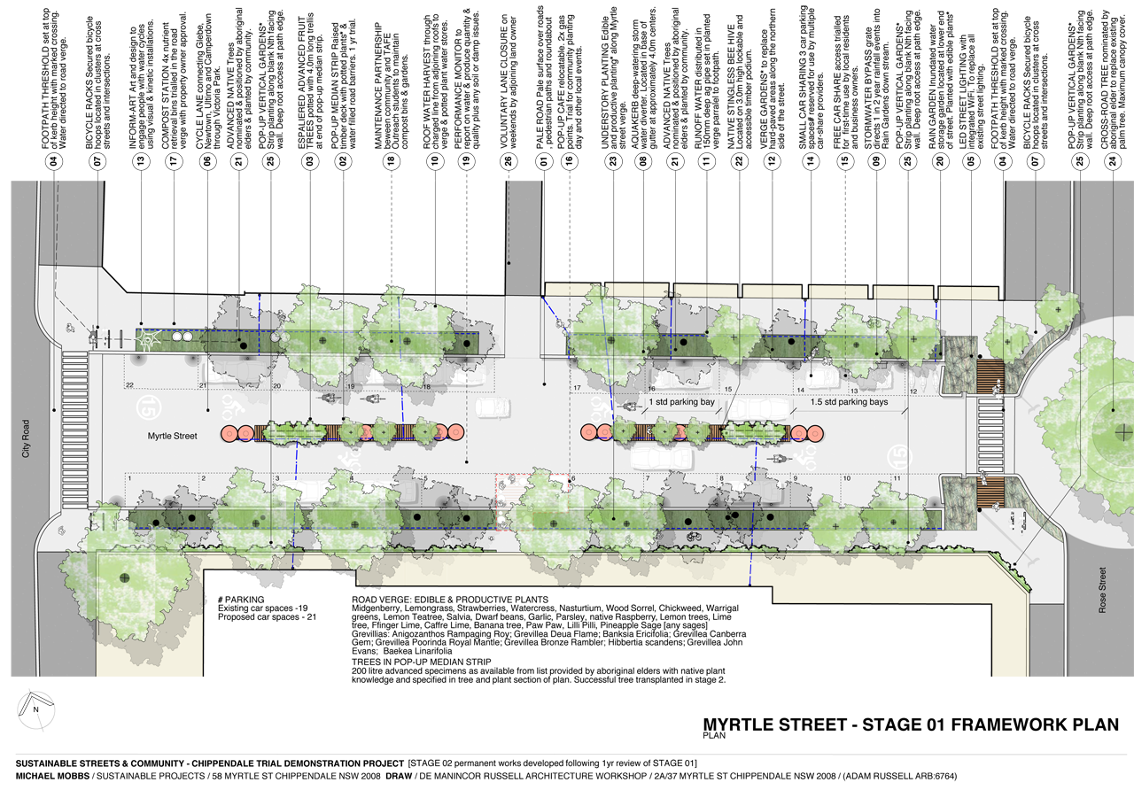
A trial self-irrigating pop-up median strip is proposed for one city block in Myrtle Street, from City Road to Rose Street. The trial will use a wide range of options and test them for effectiveness, cost and community support. One goal is to see whether it is possible to quickly cool a street and the adjoining buildings by using modular, off-the-shelf materials that are well-known to road engineers and designers. Another goal is to carry out the trial at a very low cost so that, if successful, it may be extended to other roads in the suburb at an affordable cost. Built from easily assembled and disassembled parts, the pop-up median strip offers an affordable option for cooling the city, increasing tree canopy and harvesting storm water.
Preliminary estimates indicate the pop-up median strip may be built in about 3 days. Much of the landscaping may be carried out by the community. The median strip uses readily available crash barriers, which will store water and function as large pot plants to grow native trees and other plants. The plants will be chosen with Aboriginal knowledge and planted by the local community.
Relevant objectives and actions in the 2030 Vision adopted in this Plan include:
City of Sydney Council Sustainable Sydney 2030 : Community Strategic Plan (2011), 2011Objective 4.3
Promote green travel for major workplaces and venues in the city.
Action 4.3.3
Provide bike parking, showers and change facilities for walkers and cyclists at approved City of Sydney buildings.
Walking, cycling and public transport are priorities in the 2030 Vision. They use less energy, cause less pollution, increase human health and are more affordable than travelling by privately owned car.
This Plan aims to make the car a guest in Chippendale’s streets. The suburb will be transformed into a place where children and adults may from January 2012 (original 2011 target) safely garden, walk and cycle.
The four strategies are to:
- make walking and cycling in Chippendale more attractive and practical than using a privately owned car;
- increase the places where people may walk and cycle, and where trees may be planted;
- reduce the number of cars owned and leased in Chippendale, and therefore lower the demand for parking spaces inside buildings and on roads; and
- work in partnership with government and agencies to amend road design standards where they prevent the old streets of the suburb – built before the car was invented – being used to achieve a safe and healthy village.
Walking Zone
The Plan creates a walking zone with a maximum vehicle speed limit of 15 kilometres per hour for all the roads within the project area, and a 5 kilometre per hour zone for laneways which have no footpath and where the pedestrian has right of way over the cyclist and car.
Car Parking
Three small car parking spaces are to be marked in each block in Myrtle and Meagher Streets, from City Road to Regent Street. This will create an additional 12 car parking spaces.
As this is a new concept, successful trialling will require rangers to prevent over-sized vehicles from using the spaces.
Incentives to Reduce Car Ownership
This plan has incentives to encourage residents and businesses to give up their cars, to walk and to cycle.
- Any person or business surrendering a car parking permit will be given a free 2 year car share membership top the value of 6,000 dollars per permit.
- Any household that surrenders 2 car parking permits, or a business that surrenders a car parking lease in a building for one car space, will be given a 2 year car share membership to the value of 10,000 dollars.
- Any household that surrenders one of 2 car parking permits (one of which need not be in use) will be given a free visitors’ pass entitling visitors to park for a maximum of 12 hours (2 parking infringements will void this entitlement).
- Any person in a residential block of units, or commercial building, who leases their car space to a car share scheme will be given a free car share membership for a car located in Chippendale and paid for by Council up to 2015, when this incentive will be reviewed.
- Any business that takes a car share membership from July 2011 to June 2012 will be given a free visitors’ pass entitling a visitor to the business to park for a maximum of 2 hours in the streets of Chippendale (2 parking infringements forfeit this pass).
- Any business that provides a free clean towel service for employees who cycle to and from work may claim a rate rebate of 500 dollars a year. Where the business is a tenant, the property owner may claim on behalf of the tenant who provides the service, only if the owner passes on the rate rebate to the tenant by reducing the rent by 500 dollars a year.
The aims of these incentives are to:
- increase the level of car share use from its present levels by over 20 per cent by 2015 (for both residents and businesses);
- reduce per capita car ownership;
- build on successful trials of similar initiatives elsewhere; and
collect data on outcomes.
Limited Offer
Transport incentives are limited to a trial period of 2 years or the expenditure of 90,000 dollars of Council funds, whichever occurs first.
The trial’s purpose is to investigate options for achieving the goals of the 2030 Vision and this Plan. Data about take-up and effectiveness will be reviewed and reported to Council in March 2012 and March 2013 (original 2011 targets). Recommendations will then be made about the utility and value of the trial.
Funding for trial incentives will be sourced from car parking infringements within the project area (income from which presently grosses over 30,000 dollars a month) and, if necessary, from general revenue.
Conditions of Eligibility
To be eligible for a car share rebate or a visitors’ permit, residents or businesses will need:
- proof of residency or employment in the Chippendale project area;
- proof of membership of one or more car share service providers in the area; and
- agreement to provide full details of actual car share use, including use of any car space within a residential units car park, which Council will publish while keeping the identities of participants confidential.
An application form is available from Pine Street Creative Arts Centre, any Council office or on (The City of Sydney Council’s website).
Trial Car Share Promotion
Two or more events — to be held by Council before March 2012 (original 2011 target) — will promote car share and bicycle use. The Plan intends that each of these events will attract at least 50 new car share memberships by residents and at least 10 by local businesses. Council will invite all car share service providers in Australia to participate and provide free trial membership enrolments on the day so people can learn by doing.
Shared Zone
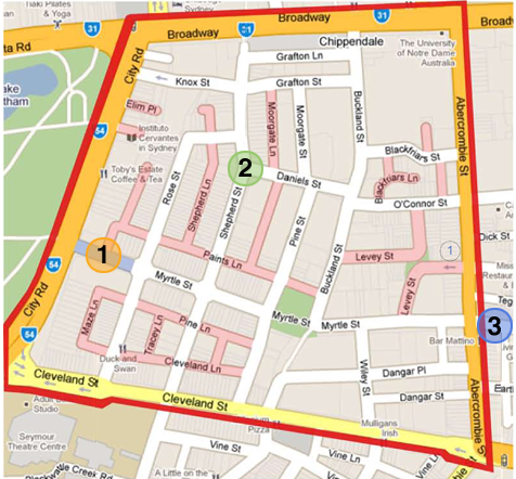
The Plan, from December 2011 (original 2011 target), creates a trial shared zone for streets and lanes in the whole project area, bounded by Broadway, City Road, Cleveland and Abercrombie Streets, using least cost design and maintenance options.
Within this area roads will be shared by cars, bicycles and pedestrians. All vehicles will be limited to walking speed, with a maximum speed of 15 kilometres per hour for cars and trucks. Cars must give way to pedestrians.
Trial Voluntary Weekend Lane Closures
The Plan trials weekend lane closures in some streets of Chippendale. On weekends during the year ending June 2012, the lanes shown on The Plan (above) may be closed to all vehicles, except residents and businesses whose properties adjoin the closure.
Any business or resident whose property adjoins the lane closure, and displaying a resident parking or access sticker issued by Council, may drive their car during the closure if access is essential for an emergency, health reasons or due to urgent business that can only be done during the lane closure.
The closures for participating lanes commence at 5:00 p.m. on Fridays and cease at 9:00 a.m. on Mondays, by which times the temporary closure devices (witches hats and barriers) must be installed and removed. Witches hats, temporary road barriers and other equipment will be stored at the Pine Street Creative Arts Centre and managed by 2 representatives of the lane who volunteer to close the lane.
Residents and businesses can initiate lane closures for lanes adjoining their properties if over 50 per cent of property owners on the lane agree. Four weeks prior to the proposed closure date, a letter must be submitted to Council which includes the following:
- nomination of at least 2 property owners to be the contact point and responsible for the closing and opening of the lane;
- signatures of at least 6 property owners confirming they have attended a road closure workshop provided free of charge by Council (which will provide instruction in how to close and open a lane, how to place, remove and store witches hats and temporary road barriers, and how to circulate letters of information about the closure);
- agreement to carry out the lane closure after Council has published the proposed land closure and obtained a response;
- agreement to provide a report on Council’s website on the impacts of the closure upon access to the properties affected within one week of the closure being carried out; and
- a plan showing the area to be closed and the location of the witches hats and temporary road barriers.
Council will undertake to publish such notice within 14 days of receiving the letter from the residents and businesses.
An emergency passage of at least 2.5 metres width shall be maintained for the whole of the length of any lane closure.
This plan implements weekend lane closures in the first year and further weekend closures subject to review of the trial.
Myrtle Street Stage One Framework Plan
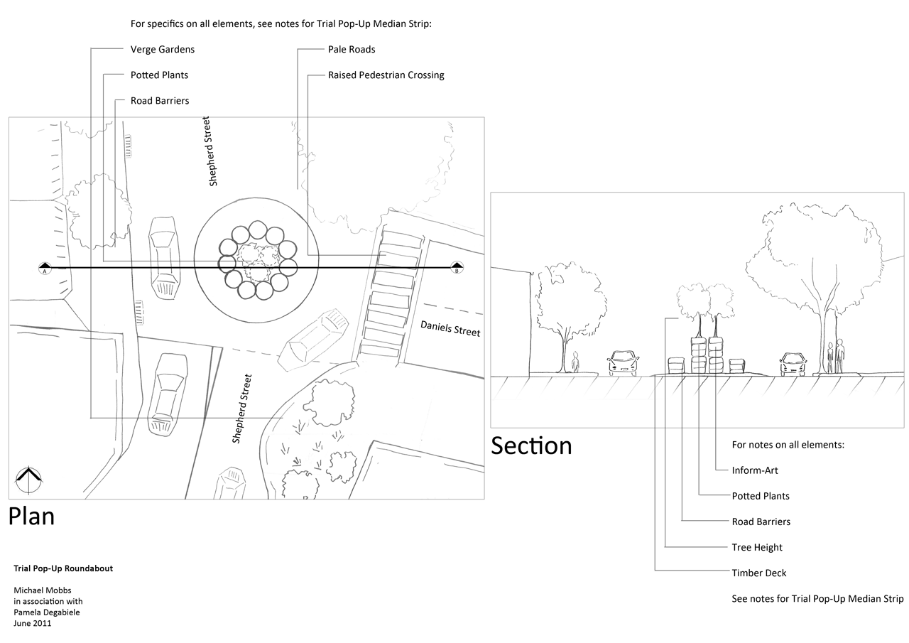
Trial Pop-Up Median Strips and Roundabouts
A pop-up median strip will be trialled in Stage One (by June 2012) as shown in the drawings at the beginning of this chapter. In Stage Two (July 2012 to June 2013) trial pop-up median strips may become permanent, and other pop-up median strips may be trialled in the suburb.
A pop-up roundabout will be trialled in Stage One at the intersection of Shepherd and Daniels Streets as shown in the drawing below.
Street Cleaners, Parking Inspectors, Rangers and the Community
Changes in the Plan to roads and Peace Park require us to re-visit the roles, powers and duties of citizens and Council.
Parking inspectors, street cleaners and rangers work in the city’s streets. Thus, the streets are the front office of Council and these workers are key ambassadors: the eyes, ears and face of Council. These workers have the potential to significantly support this plan. If the Plan is to be successful it is essential to review these roles by consultation. Goals of the process include:
- increase levels of engagement, understanding and cooperation between the community and garbage collectors, parking inspectors, street cleaners, rangers and any contractors working in the streets and parks;
- prevent theft of and damage to fruit trees and road verge gardens;
- promote harvesting of road verge produce by garbage collectors, parking inspectors, street cleaners and rangers;
- achieve joint planting days in road gardens;
- recycle leaves and fallen branches in local road compost and mulch bins;
- see published results of Council imposing fines for parking in car-share parking places and small car parking spaces; and
- have a mechanism whereby the General Manager collects data on outcomes for these goals and publishes them in the General Manager’s annual report about the Plan (this annual report is due to Council commencing February 2012 and annually thereafter).
Pollution Levy
The following initiatives will be explored with the state government and solutions implemented in year two of The Plan.
Car registration fees to pay for car pollution of water and land
Car owners will pay for vehicle pollution via a 5 dollar fee for vehicles registered in Chippendale. This will be matched by proportional state funding for bus pollution from state transport agencies.
Commencing October 2011 (original 2011 target) the registration fees so raised and the proportion of the state’s contribution will be paid quarterly to Council for the purposes of this Plan. An exception is allowed where the state first publishes an account showing those monies, or a portion of them, that are not given to Council have been spent on projects related to this Plan by a state government agency or corporation.
This system obtains money to pay for projects in this Plan that are partly required to redress pollution from privately and publicly owned vehicles in Chippendale, including Council and Council contractor vehicles.
The General Manager will report progress to Council and where there is no progress will provide reasons and suggest solutions.
Getting Around
Under the Plan the Chippendale area – bounded by Broadway, Abercrombie Street, Cleveland Street and City Road – will include:
- voluntary lane closures;
- a shared zone for pedestrians, cyclists and cars;
- cool streets in summer due to pale roads, more tree cover and pale roofs;
- trial bicycle lanes and routes; and
- car spaces reserved for small cars.
- Pop-up median strip
- Pop-up roundabout
- Pale road surface
stretching from City Rd along Myrtle St to Abercrombie St, and then on from Abercrombie St along Meagher St to Regent St
Voluntary lane closures are marked in red.
Trials
- Pop-up cafes that are 7 metres long and 1.5 metres wide: Levey Street and Abercrombie Street, and as part of the pop-up median strip trial in Myrtle Street from City Road to Rose Street.
- Shared zone: all roads in the whole of the area to which the Plan applies will have a maximum speed limit of 15 kilometres per hour and cars give way to pedestrians.
- Volunteer weekend lane closures: when residents and businesses wish to they may close a lane with no footpath but allow local cars and deliveries through.
- Lanes will have a 5 kilometre per hour speed limit.
Pop-Up Roundabout
Sydney Water and Council to Trial Water Saving Options for Roads & Buildings
Council will offer to partner with Sydney Water and the businesses and residents of Chippendale to trial demonstration projects in the year ending June 2012. The aim is to cool the suburb in summer by increasing vegetation and tree canopy cover, improve air quality, and reduce water use. A range of projects are proposed as part of the Plan. The whole of government and other agencies approach to the project includes goals to:
reduce water and energy use, and water and energy bills; and
cool Sydney’s suburbs and thereby improve health of communities.

An illustration of a self-irrigating pop-up median strip and road verge.
Strategic Value to Sydney Water and Sydney’ Resources
The projects with Sydney Water will mean less demand for water for irrigation, less evaporation and pollution of reservoir and channel waters. Sydney Water will undertake the following projects.
- Fund and support a trial of a storm water grate bypass for use in the one block trial of a sustainable road. The grate will be capable of fitting on grates in Sydney, the Blue Mountains and Wollongong. It will direct rainwater from the one in 2 year events (low flows) past the storm water pit to be used in making the road verges self-irrigating. The cost estimate for the design, trial and monitoring is 10,000 dollars.
- End storm water charges in the project area for any property installing, or which has installed, a tank to store in excess of 21,000 litres of rainwater. As long as that water is entirely for internal use.
- Promptly facilitate the disconnection from mains water or sewer of any residential or commercial property which volunteers to disconnect. Upon disconnection, end fixed charges for those services.
- Supply water meters free of charge to any residential unit which volunteers to install the meter and commence paying water usage charges to Sydney Water.
- Publish data on water, energy and financial savings achieved from these trial projects.
Cool Streets
This plan creates a cool road in Myrtle Street from City Road to Abercrombie Street, and in Meagher Street from Abercrombie to Regent Street. Those two streets will be resurfaced as pale roads. Data will be published in the General Manager’s report to Council in February 2012 (original 2011 target) about the impact of the works on temperatures, tree canopy, air conditioning use and comfort levels in adjoining properties.
Trial Pop-Up Cafes
This plan creates pop-up cafes to be trialled in at least 2 locations (Myrtle Street between City Road and Rose Street, and in Levey Street at the intersection with Abercrombie Street). For further details see the food chapter of this Plan.
Least Cost Design, Construction and Maintenance
All construction drawings and specifications for road and other trial projects will demonstrate least cost for all aspects of the project. Peer and community review will be conducted during the design process. Community participation in design workshops is essential to achieve least cost projects and community engagement.
For example, we estimate that over 2 million litres of rainwater can be kept where it falls on the Single Block Trial Demonstration Project at a capital cost of less than 300 dollars. This will pay for the purchasing and installation of agricultural pipe. Community gardeners will volunteer to install and maintain the pipes. The pipes will enable road verges to be self-irrigating and meet the needs of plants.
Each drawing submitted to Council for approval for a trial project in The Plan will include the following statement on the title block.
This drawing includes or is supported by other documents with:
- specifications for use of local, community provided or recycled materials such as local compost, bricks, tar, concrete, timber or other materials;
- specifications for the use of community labour for the installation, construction and maintenance of vegetation, street furniture, compost bins or other items;
- specifications for all materials used during construction, including food and beverages consumed by the community and contractors (if any) to be recycled;
- an estimate of maintenance costs and responsibilities by the community and/or Council;
- a certificate submitted with any invoice relating to all drawings and documents which includes this statement: ‘The works, services and materials that are the subject of this invoice were provided to ensure least cost construction and maintenance, including specific provision for community delivery of maintenance services, and were peer reviewed by the community and any nominated third party prior to the submission of this invoice.’
Demonstration Project Timelines
This timeline is based on the original 2011 target start date for The Plan. It will have to be updated for implementation.
Immediately
- Voluntary trial weekend lane closures for volunteering locals.
December 2011
- Trial shared zone for entire project area.
Stage One Construction by January 2012
- Cool one city block using full range of options for growing food, self-irrigating pop-up median strip and verges, low cost rain gardens, over 40 per cent tree canopy cover and other techniques.
- Cool over 12 city blocks using pale road surface.
Stage Two Construction by January 2013
- Design to be developed from the outcomes and monitoring of Stage One works.
Cost
The total cost of the trials in this transport plan is estimated at 390,000 dollars. Those monies will firstly be drawn from car parking fines relating to the area in the Plan. Such fines produce an income exceeding approximately 360,000 dollars a year.
Benefits
The benefits will be quantified within the annual report to Council by the General Manager. They are expected to include the following for Myrtle Street between City Road and Abercrombie Street, and Meagher Street between Abercrombie and Regent Street:
- an about 2 degree Celsius temperature drop in summer days exceeding 30 degrees Celsius;
- a saving of about 5–10 per cent in air conditioning bills in residential and commercial properties adjoining the cool road, or an estimated saving in bills totalling 10,000–20,000 dollars in the first year;
- a reduction in Myrtle and Meagher Streets in vehicle-made air pollution (including particulates) by 2–5 per cent;
- the prevention of over 4 million litres of stormwater polluting Blackwattle Bay;
- a saving of at least 5,000 dollars for participants from avoided car ownership costs due to increased use of car share, walking and bicycling instead of private car use;
- for those growing food, buying through local farmer box schemes or buying from the markets in Peace Park a saving in food bills of over 500 dollars a year (in avoided transport, food wastage, garbage and related costs);
- quieter streets with more conversations; and
- growing understanding across all ages and nationalities of residents, businesses and workers of the 2030 Vision and the need for it to succeed.
In the report the General Manager will provide an estimate of the value of these savings if they were applied across the Council area.
Ask not what your council can do for you.
Ask what you can do for your neighbours, house, building, street or council.